
")
Text and Photos by Henrylito D. Tacio
(Second of Three Parts)
A long, long time ago, the Philippines was totally covered with forest.
“A few hundred years ago, at least 95 percent of the Philippines was covered by rain forest; only a few patches of open woodland and seasonal forest, mostly on Luzon, broke the expanse of moist, verdant land,” wrote Dr. Lawrence R. Heaney, an American ecologist and biogeographer of the Field Museum of Natural History of Chicago.
By the time Ferdinand Magellan “rediscovered” the country on March 16, 1521, scattered coastal areas had been cleared for agriculture and population dwellings. Three hundred years later, the rainforest still covered about 70 percent of the country.
Today, the Philippines is almost devoid of its forest cover. According to the UN Food and Agriculture Organization (FAO), 25.7 percent or about 7,665,000 hectares of the country’s total land area of 30 million hectares is forested. Of this, 11.2 percent (861,000) hectares) is classified as primary forest.
Between 1990 and 2010, the Philippines lost an average of 54,750 hectares or 0.83 percent per year. “Most of the (Philippines’) once rich forest are gone,” said the FAO publication, Sustainable Forest Management. “Forest recovery, through natural and artificial means, never coped with the destruction rate.”
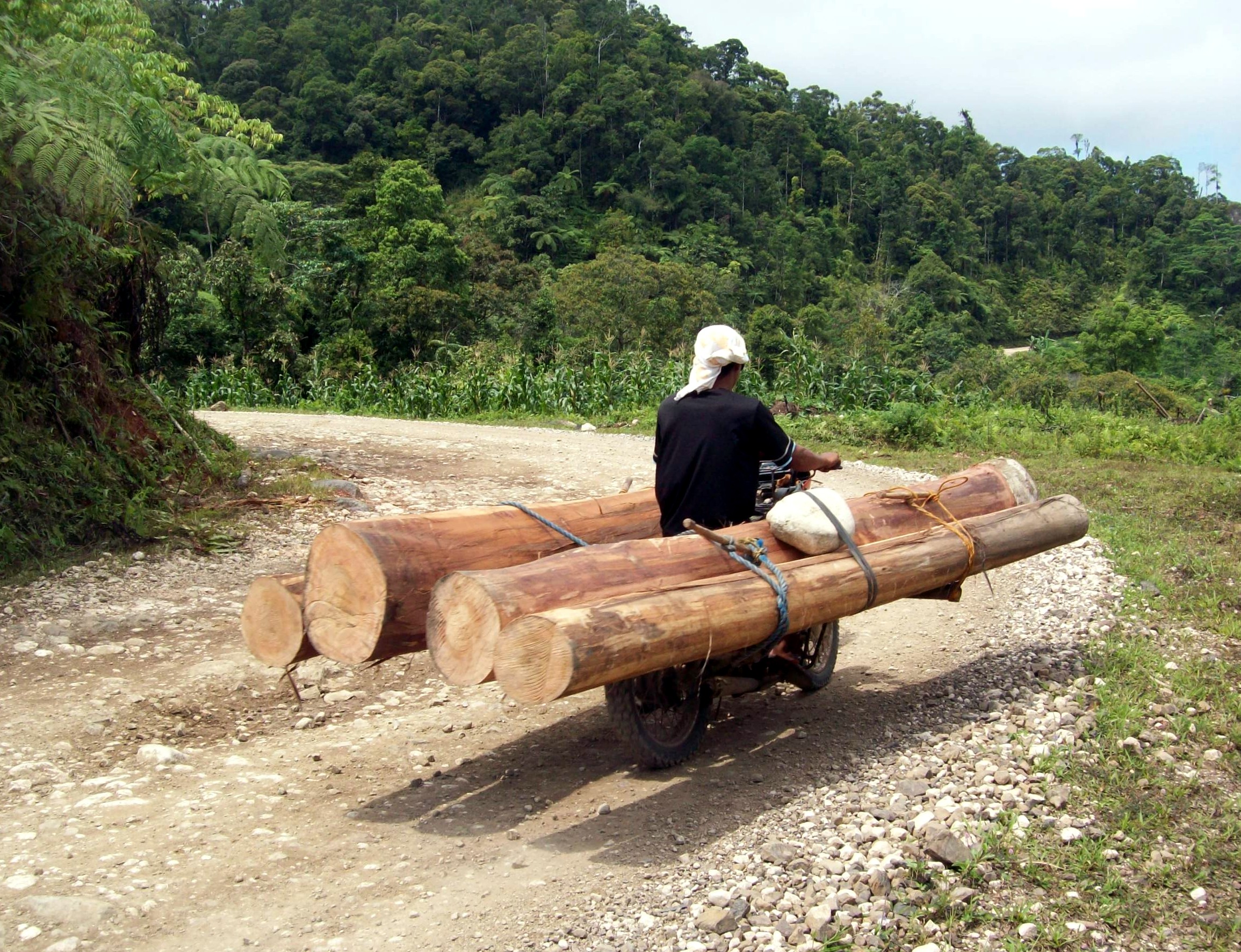
According to the Department of Environment and Natural Resources (DENR), the principal cause of the decimation of the country’s forest cover are logging (both legal and illegal), forest fires, natural calamities (like an earthquake), as well as conversion to agricultural lands, human settlements, and other land, uses brought about by urbanization and increasing population pressure.
Additional threats to Philippine forests come from mining operations – which also cause pollution – a collection of fuel wood (85% of meals in developing countries are cooked over wood or charcoal), and kaingin farming (slash-and-burn agriculture).
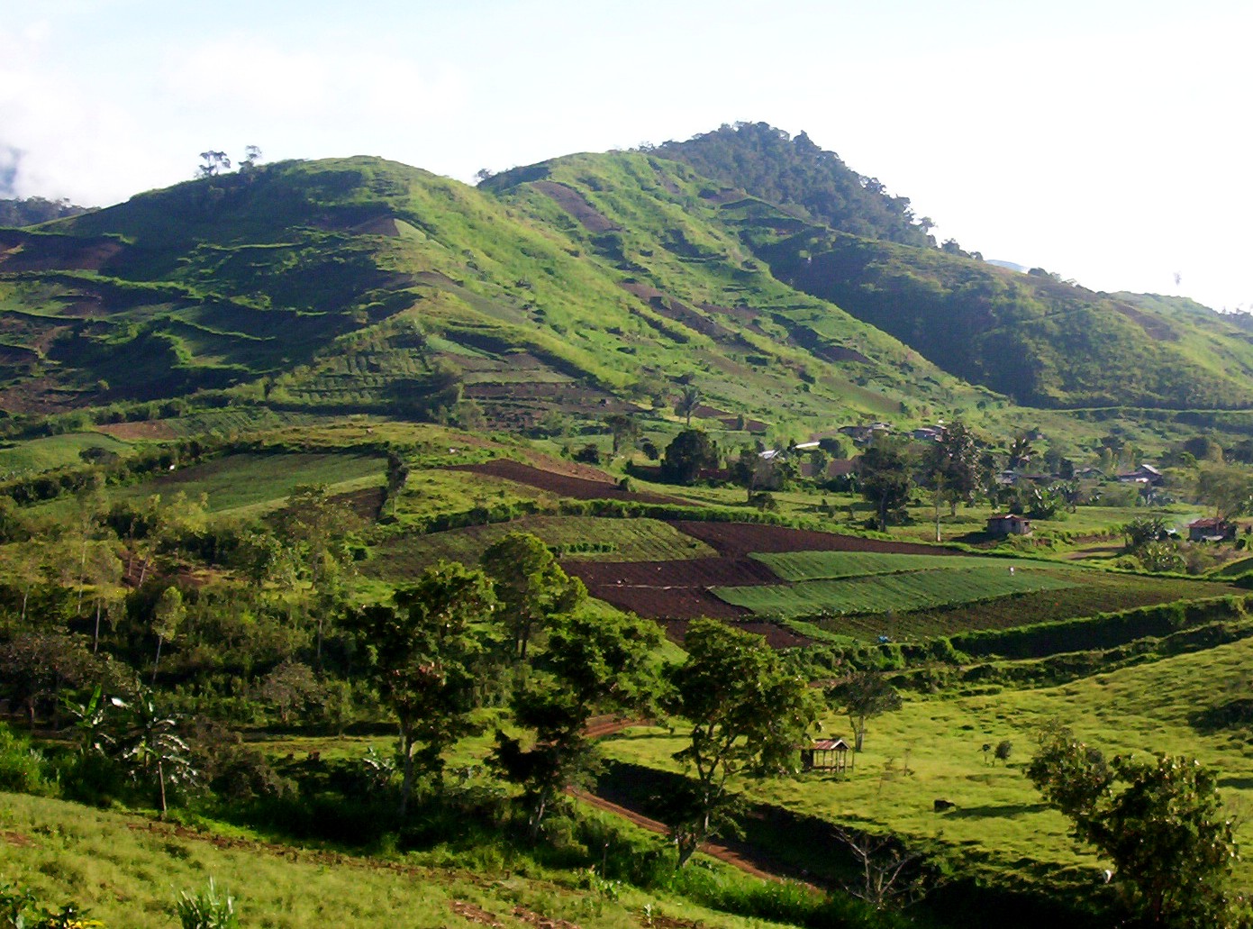
Most of the remaining forests these days are located in upland areas or those rolling and steep lands with slopes ranging upward from 18%. At least 60% of the country’s total land area of 30 million hectares is considered uplands.
Some of these uplands are already being tilled by farmers. “It is in the uplands where supplementary and additional food sources will be grown,” wrote Charles Castro in his position paper, Uplands, and Uplanders: In Search for New Perspective. “It is in the uplands which will give Filipinos temporary elbow room for the land shortage. It is in the uplands where landless rural people will find a new option in fighting rural poverty.”
“Three out of four farmers in developing countries farm in the hills,” said Harold R. Watson, former director of the Davao-based Mindanao Baptist Rural Life Center (MBRLC) Foundation, Inc., when he accepted the Nobel Prize of Asia in 1985. “When they hold a fistful of exhausted soil and let it fall to the ground, they feel their livelihood slipping through their fingers.”
He continued: “Land degradation is a problem affecting the standard of living of many nations, especially on the millions who live on and farm the hillsides. I call on people everywhere to help stem the tide of this wave of destruction while there is still time.”
To help the problem of deforestation, soil erosion, low crop production, and hunger, the MBRLC developed SALT 3, a modification of the original one-hectare Sloping Agricultural Land Technology (SALT 1). SALT 2, or Small Agro-Livestock Technology, refers to raising goats to address the malnutrition problem, which is common among upland farmers.
In SALT 3, one hectare is developed for various agricultural crops. Following the SALT 1 principle, different nitrogen-fixing trees and shrubs (like the local “ipil-ipil” and “kakawate” and introduced species such as Flemingia macrophylla, Desmodium rensonii, and Indigofera anil) are planted in double rows, following their natural contour.
“The principle of SALT is the same as that used by the Ifugao tribes in Mountain Province,” says Jethro P. Adang, the current director of MBRLC. “All we are doing is using various nitrogen fixing trees and shrubs instead of rocks.”
When the rows of vegetation are 1.5 to 2 meters tall, they are cut back to about 40 centimeters, and the tops are piled in the 3- to 5-meter alleys where crops are growing. “The leaves of the shrubs make very good nitrogen-rich fertilizer and also add organic matter to the soil,” Adang points out.
In the SALT scheme, you find a mix of permanent crops, cereals, and vegetables. Every third strip of available land is normally devoted to permanent crops like cacao and coffee. A combination of various cereals (corn, upland rice, and sorghum) and vegetables (string beans, cucumber, squash, etc.) are planted on the remaining two strips of land.
MBRLC recommends crop rotation. For instance, those strips planted with cereals earlier are planted with peanuts or winged beans in the next cropping. “Crop rotation helps to preserve the regenerative properties of the soil and avoid the problems of infertility typical of traditional agricultural practices,” Adang says.
Multistory cropping may also be practiced (planting black pepper, corn, and lanzones together in one hedge). In waterlogged areas, gabi, kangkong, and other water-loving crops are planted. “We all do these to make use of all the available spaces of the farm,” Adang says.
“Some of the crops should be planted to feed the farmer’s family, while other crops are grown for sale, so family income is well spread out over the season,” says Adang. “Every week or every month, there’s always something to harvest. The system can, in fact, raise the family income threefold.”
One foreign consultant who came to see the agricultural component of SALT 3 commented: “The system provides great stability (in both economic and ecological terms) and appears to conserve soil very well in the process of growing useful plants.”
However, MBRLC encourages that only one hectare is planted to crops. This is where the farmer will concentrate more as years go by. However, the upper portion of the farm is planted with different trees which are native to the area.
Adang talked about “tree time zones” of 1-5, 6-10, 11-15, and 16-20 years, within which progressively more valuable products are harvested. Some very valuable trees could be left longer, and he dubs this “the grandchild project – plant something for your grandchildren.”
Among the tree species planted in the SALT 3 model farm are bamboo, Sesbania sesban, “ipil-ipil,” Acacia auriculiformis and A. mangium, Swietenia macrophylla, Pterocarpus indicus (more popularly known as narra), and Samanea saman (rattan is planted below it). Some of these are planted basically for fuelwood, while others are for furniture purposes.
Meanwhile, Watson believed that just like the prophet David who defeated the leviathan Goliath with just a slingshot and a stone, going back to the basics could solve the problems. “We do not need modern technologies and high-tech gadgets to defeat the enemy. All we have to do is use what God has provided us throughout the years,” he said.
Through the years, MBRLC has received several recognitions from various government agencies, including the Department of Agriculture (DA), Department of Environment and Natural Resources (DENR), Department of Agrarian Reform (DAR), and Department of Science and Technology (DOST).
In 1991, the MBRLC was recognized by the UN Food and Agriculture Organization with a World Food Day Silver Medal “in recognition of the contribution to mobilizing people’s participation in tree planting and sustainable forest resources management.”
“Only when the last tree has been cut, the last river poisoned, and the last fish caught will we realize we can’t eat money,” so goes a Native American proverb. (To be concluded)
Text and Photos by Henrylito D. Tacio
(Second of Three Parts)
A long, long time ago, the Philippines was totally covered with forest.
“A few hundred years ago, at least 95 percent of the Philippines was covered by rain forest; only a few patches of open woodland and seasonal forest, mostly on Luzon, broke the expanse of moist, verdant land,” wrote Dr. Lawrence R. Heaney, an American ecologist and biogeographer of the Field Museum of Natural History of Chicago.
By the time Ferdinand Magellan “rediscovered” the country on March 16, 1521, scattered coastal areas had been cleared for agriculture and population dwellings. Three hundred years later, the rainforest still covered about 70 percent of the country.
Today, the Philippines is almost devoid of its forest cover. According to the UN Food and Agriculture Organization (FAO), 25.7 percent or about 7,665,000 hectares of the country’s total land area of 30 million hectares is forested. Of this, 11.2 percent (861,000) hectares) is classified as primary forest.
Between 1990 and 2010, the Philippines lost an average of 54,750 hectares or 0.83 percent per year. “Most of the (Philippines’) once rich forest are gone,” said the FAO publication, Sustainable Forest Management. “Forest recovery, through natural and artificial means, never coped with the destruction rate.”
According to the Department of Environment and Natural Resources (DENR), the principal cause of the decimation of the country’s forest cover are logging (both legal and illegal), forest fires, natural calamities (like an earthquake), as well as conversion to agricultural lands, human settlements, and other land, uses brought about by urbanization and increasing population pressure.
Additional threats to Philippine forests come from mining operations – which also cause pollution – a collection of fuel wood (85% of meals in developing countries are cooked over wood or charcoal), and kaingin farming (slash-and-burn agriculture).
Most of the remaining forests these days are located in upland areas or those rolling and steep lands with slopes ranging upward from 18%. At least 60% of the country’s total land area of 30 million hectares is considered uplands.
Some of these uplands are already being tilled by farmers. “It is in the uplands where supplementary and additional food sources will be grown,” wrote Charles Castro in his position paper, Uplands, and Uplanders: In Search for New Perspective. “It is in the uplands which will give Filipinos temporary elbow room for the land shortage. It is in the uplands where landless rural people will find a new option in fighting rural poverty.”
“Three out of four farmers in developing countries farm in the hills,” said Harold R. Watson, former director of the Davao-based Mindanao Baptist Rural Life Center (MBRLC) Foundation, Inc., when he accepted the Nobel Prize of Asia in 1985. “When they hold a fistful of exhausted soil and let it fall to the ground, they feel their livelihood slipping through their fingers.”
He continued: “Land degradation is a problem affecting the standard of living of many nations, especially on the millions who live on and farm the hillsides. I call on people everywhere to help stem the tide of this wave of destruction while there is still time.”
To help the problem of deforestation, soil erosion, low crop production, and hunger, the MBRLC developed SALT 3, a modification of the original one-hectare Sloping Agricultural Land Technology (SALT 1). SALT 2, or Small Agro-Livestock Technology, refers to raising goats to address the malnutrition problem, which is common among upland farmers.
In SALT 3, one hectare is developed for various agricultural crops. Following the SALT 1 principle, different nitrogen-fixing trees and shrubs (like the local “ipil-ipil” and “kakawate” and introduced species such as Flemingia macrophylla, Desmodium rensonii, and Indigofera anil) are planted in double rows, following their natural contour.
“The principle of SALT is the same as that used by the Ifugao tribes in Mountain Province,” says Jethro P. Adang, the current director of MBRLC. “All we are doing is using various nitrogen fixing trees and shrubs instead of rocks.”
When the rows of vegetation are 1.5 to 2 meters tall, they are cut back to about 40 centimeters, and the tops are piled in the 3- to 5-meter alleys where crops are growing. “The leaves of the shrubs make very good nitrogen-rich fertilizer and also add organic matter to the soil,” Adang points out.
In the SALT scheme, you find a mix of permanent crops, cereals, and vegetables. Every third strip of available land is normally devoted to permanent crops like cacao and coffee. A combination of various cereals (corn, upland rice, and sorghum) and vegetables (string beans, cucumber, squash, etc.) are planted on the remaining two strips of land.
MBRLC recommends crop rotation. For instance, those strips planted with cereals earlier are planted with peanuts or winged beans in the next cropping. “Crop rotation helps to preserve the regenerative properties of the soil and avoid the problems of infertility typical of traditional agricultural practices,” Adang says.
Multistory cropping may also be practiced (planting black pepper, corn, and lanzones together in one hedge). In waterlogged areas, gabi, kangkong, and other water-loving crops are planted. “We all do these to make use of all the available spaces of the farm,” Adang says.
“Some of the crops should be planted to feed the farmer’s family, while other crops are grown for sale, so family income is well spread out over the season,” says Adang. “Every week or every month, there’s always something to harvest. The system can, in fact, raise the family income threefold.”
One foreign consultant who came to see the agricultural component of SALT 3 commented: “The system provides great stability (in both economic and ecological terms) and appears to conserve soil very well in the process of growing useful plants.”
However, MBRLC encourages that only one hectare is planted to crops. This is where the farmer will concentrate more as years go by. However, the upper portion of the farm is planted with different trees which are native to the area.
Adang talked about “tree time zones” of 1-5, 6-10, 11-15, and 16-20 years, within which progressively more valuable products are harvested. Some very valuable trees could be left longer, and he dubs this “the grandchild project – plant something for your grandchildren.”
Among the tree species planted in the SALT 3 model farm are bamboo, Sesbania sesban, “ipil-ipil,” Acacia auriculiformis and A. mangium, Swietenia macrophylla, Pterocarpus indicus (more popularly known as narra), and Samanea saman (rattan is planted below it). Some of these are planted basically for fuelwood, while others are for furniture purposes.
Meanwhile, Watson believed that just like the prophet David who defeated the leviathan Goliath with just a slingshot and a stone, going back to the basics could solve the problems. “We do not need modern technologies and high-tech gadgets to defeat the enemy. All we have to do is use what God has provided us throughout the years,” he said.
Through the years, MBRLC has received several recognitions from various government agencies, including the Department of Agriculture (DA), Department of Environment and Natural Resources (DENR), Department of Agrarian Reform (DAR), and Department of Science and Technology (DOST).
In 1991, the MBRLC was recognized by the UN Food and Agriculture Organization with a World Food Day Silver Medal “in recognition of the contribution to mobilizing people’s participation in tree planting and sustainable forest resources management.”
“Only when the last tree has been cut, the last river poisoned, and the last fish caught will we realize we can’t eat money,” so goes a Native American proverb. (To be concluded)