
")
Text by Henrylito D. Tacio
Photos: DOST and Wikipedia
In the Philippines, disasters are not waiting to happen; they happen every now and then.
As Kathleen Tierney, director of the Natural Hazards Center at the University of Colorado, puts it: “The Philippines is one of the most disaster-prone places on Earth. They’ve got it all. They’ve got earthquakes, volcanoes, floods, tropical cyclones, landslides.”
“The Ring of Fire” – that’s how scientists call the area in the basin of the Pacific Ocean where a large number of earthquakes and volcanic eruptions occur.
Unfortunately, the Philippines – a country with 7,107 islands – is located in this rim, sometimes called the circum-Pacific seismic belt. About 90 percent of the world’s earthquakes and 81 percent of the world’s largest earthquakes occur along the Ring of Fire.
Each year, about 6,000 earthquakes are detected throughout the world. That’s according to Grolier Encyclopedia. Of the total, 5,500 are either too small or too far from populated areas to be felt directly. Another 450 are felt but cause no damage, and 35 cause only minor damage. The remaining 15, however, exact a great toll in death and suffering, besides heavily damaging houses, buildings, and other structures.
An earthquake (also known as a quake, tremor, or temblor), according to a monograph circulated by the Philippine Institute of Volcanology and Seismology (Phivolcs), “is feeble shaking to violent trembling of the ground produced by the sudden displacement of rocks or rock materials below the earth’s surface.”
Phivolcs, which is under the Department of Science and Technology (DOST), is the government agency tasked to do studies on earthquakes that occur throughout the country. To do this, scientists use seismographs, instruments that record the vibrations caused by earthquakes.
The Philippine Archipelago lies between two major tectonic plates: the Philippine Sea Plate and the Eurasian Plate. “Philippine Sea Plate is moving towards the Philippine Archipelago at the rate of about 7 centimeters every year,” Phivolcs explains. “The Eurasian Plate is being subducted along western side of Luzon and Mindoro at the rate of 3 centimeters per year except on Mindoro and northwest of Zamboanga where collision is taking place.”
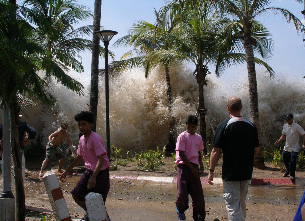
Tsunami after an earthquake (Photo from Wikipedia) 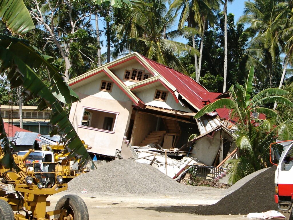
Earthquake destroyed house in Bohol (Photo from Wikipedia)
At the intersection of the two aforementioned plates is the Philippine Fault Zone, “which decouples the northwestward motion of the Pacific with the southwestward motion of the Eurasian Plate.” Movements along other active faults are reportedly responsible for the present-day high seismicity of the Philippine Archipelago.
According to Phivolcs, at least five earthquakes per day occur in the Philippines. For almost four decades now, the country has been affected by ten earthquakes with magnitudes greater than 7.0. As such, the possibility of these destructive earthquakes occurring again in the future “is very strong.”
“The only way to avoid disasters caused by earthquakes is to prepare for them,” wrote Maria Elena Paterno in her book Earthquake!
This is the reason why the Phivolcs inaugurated the Phivolcs Mindanao Cluster Monitoring Center for Earthquake and Tsunami (PMCMCET) facility in Davao City last September 24, 2022, via a virtual presser.
According to Phivolcs, the main objective of putting a new facility is “to provide capable nationwide earthquake and tsunami monitoring that would ensure continuity of operations when the main office located in Quezon City failed to function immediately after an emergency or disruption.”
The 20-million facility features a near real-time display of the Philippine Seismic Network upgraded computer systems for earthquake and tsunami data acquisition and processing and newly-installed tools for decision support, mapping, and information dissemination.
Some of the equipment housed in the facility include the following: satellite dish, solar panel, broadband seismometer, strong motion sensor, data receiving center, earthquake monitoring system, Philippine seismic network, automated earthquake solution, real-time earthquake waveforms, tsunami monitoring system, and trans-Pacific sea level, tsunami monitoring websites.
The newest earthquake and tsunami monitoring center is located at the Philippine Science High School – Southern Mindanao Campus in Mintal, Davao City. It is envisioned to be beneficial not only for monitoring activities but also to serve as a facility for students’ education in the region.
“Putting up this facility would not only benefit the residents from Davao City but also the rest of Mindanao Island. The decisions and policies made by different LGUs could be guided by real-time data and scientific studies provided by this monitoring facility,” said Dr. Renato U. Solidum Jr., Phivolcs officer-in-charge and DOST undersecretary for scientific and technical services.
In her video message, Davao City Mayor Sara Durterte-Carpio commended DOST-PHIVOLCS for continuously fulfilling its mandate to mitigate the risks of natural hazards and avert disasters by providing accurate and timely information on disaster preparedness and risk reduction.

“By establishing the first Mindanao earthquake and tsunami monitoring center in Davao City, you further widen the scope of the affected public service delivery especially in terms of predicting volcanic eruptions, earthquakes, and tsunamis as well as formulating disaster preparedness action plan to mitigate possibly the greater risks here in Mindanao,” said Duterte-Carpio.
Chief Alfredo D. Baloran of the Davao City Disaster Risk Reduction and Management Office likewise welcomed this initiative. He said that PMCMCET would play a crucial role in helping them to have better planning, response, and policies, especially after experiencing succeeding earthquake-related events during the latter part of 2019 up to the first few months of 2020.
In the virtual presser, DOST Secretary Fortunato T. de la Peña stressed that the department has always pushed for better appreciation of scientific information to transform people’s lives.
“With the inauguration of this cluster center, we hope to bring the products and services of our earth science team in our department closer to the people whom we serve, and they will truly appreciate the meaning of earth sciences sa rehiyon at sa local level,” Sec. de la Peña said.
To further improve its earthquake and tsunami monitoring efforts, Usec. Solidum revealed that there would be a similar facility to be built in San Fernando, Cebu, in six months.
The agency aims to have a total of 115 seismic stations by 2022.