

Text and Photos by Henrylito D. Tacio
(Second of Two Parts)
Just like the very popular American television sitcom, Three’s a Company, disaster is also like that. In the Philippines, disaster comes together in three forms: when there’s a typhoon, expect too much rain, and inundating floods.
Typhoons Sendong and Pablo, which hit Mindanao, were only a preview of the things to come. Both were described as “super typhoons,” thus they caused extensive devastation to Northern Mindanao (particularly the cities of Cagayan de Oro and Iligan) and Southern Mindanao (mostly in Davao Oriental and Davao de Oro).
In the last several years, the country has suffered extreme weather events, including long dry spells, heavy rains as well as strong typhoons, and floods. Of these events, the most familiar is floods.
“Floods are due to the complex combination of weather, climatic and human activities,” explained Rosalie Pagulayan, weather specialist II of the Philippine Atmospheric, Geophysical and Astronomical Services Administration (PAGASA) during a seminar-workshop convened by the Department of Science and Technology (DOST) in Davao City some years back. “Most floods occur as a result of moderate-to-large-scale rainfall events.”
“Floods are among the most destructive calamities man has to cope with,” the weather bureau adds.
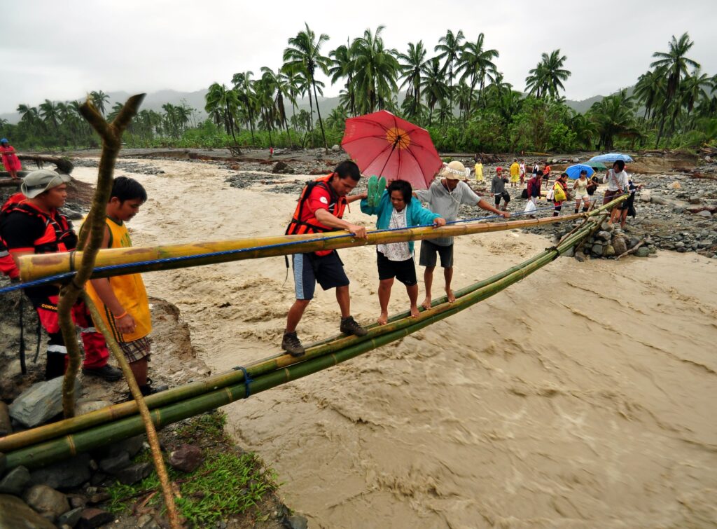
A really big flood can result in millions, even billions of dollars of damages to roads and bridges, buildings and other economic infrastructure, in the loss of agricultural crops and livestock, loss of productivity in industry, commerce, and trade – not to mention the incalculable loss of human life.
Floods are likely to create havoc among informal settlers, which account for 45% of the country’s urban population. “(They) are particularly vulnerable to floods due to less secure infrastructure, reduced access to clean water, and lack of health insurance,” a World Bank report says.
In 1991, Ormoc City in Leyte was once devastated by a colossal flood, killing about 8,000 people, wherein half of the victims’ bodies were never recovered. Walls of mud and water emanating from the mountain washed away shanties and swept people into the sea, a tragedy that brought lamentations all over the place and in the whole Philippines. It was news all over the world.
Science Secretary Fortunato dela Peña cited climate change as the primary culprit of the sudden surge of stronger floods in recent years. “Climate change is one of the reasons why floods have become intense and consistent these days,” he said.
In the past, people blamed deforestation as the most likely cause of floods. But Dr. Patrick Durst begged to disagree with this conventional wisdom. In an exclusive interview some years back, he said there is no scientific evidence to link major, large-scale floods to the loss of forests.
“Government officials, aid groups and the media are often quick to blame flooding on deforestation caused by small farmers and tree cutters,” said Dr. Durst, who was then the regional forestry officer of the UN Food and Agriculture Organization (FAO).
He said that such ideas have, in the past, led some governments to force poor farmers from their lands and away from forests while doing nothing to prevent future flooding. “Such actions are totally misguided,” he pointed out.
Are floods caused by nature or by human activities like logging? It’s a hard question to answer, but Forests and Floods: Drowning in Fiction or Thriving on Facts? tries to separate fact from fiction on issues related to forests and water. The FAO publication also dispels some of the commonly held misconceptions about the role of forests in flood mitigation.
“Clearly, floods are caused by nature; but in some cases, they are exacerbated by human activities,” Dr. Durst said.
“The floods blamed on deforestation almost always occur after prolonged rains, which saturate the soil, including forest soil, so that it can no longer absorb more water,” explained the 30-page FAO report. “Rain then has nowhere to go but into rivers where it fills them to overflowing.”
At its root, the flood equation is pretty simple: If a river cannot handle the load of water it’s required to carry, it must rise. With enough water, it must rise above its banks and flood. The faster water runs from the watershed into the river, the higher a flood will be. Thus, anything that increases runoff speed – like excessive pavement or ditching of farmland – will contribute to floods.
Dela Peña, however, believes the climate-change typhoons are the harbinger of floods. From 1990 to 2006, for instance, the Philippines experienced record weather-related disasters, including the strongest typhoons, the most destructive typhoons, the deadliest storm, and the typhoon with the highest 24-hour rainfall on record.
“These events are projected to continue to intensify, requiring the Philippines to improve its climate resilience and develop its adaptive capacity to alleviate the risk of catastrophic economic and humanitarian impacts,” the World Bank report suggests.
One government official puts it: “There is no better way of protecting our people from floods, landslides and other hazards brought by typhoons than making them aware and ready on what to do when these situations arise.”
Mindanao is home to more than 22 million Filipinos. Most of them are affected by weather-related disasters. As such, the DOST has launched the Geo-Informatics for the Systematic Assessment of Flood Effects and Risks Towards a Resilient Mindanao or Geo-SAFER Mindanao. It is initiated by five higher education institutions: Ateneo de Zamboanga University (AdZU), Central Mindanao University (CMU), Mindanao State University – Iligan Institute of Technology (MSU-IIT), Caraga State University (CSU), and University of the Philippines – Mindanao (UP-Min).
Actually, Geo-SAFER is an expansion of the Phil-LIDAR 1 Project that aims to produce highly detailed flood hazard maps. Using the state-of-the-art technology of Light Detection and Ranging (Li-DAR) equipment, it can generate detailed topographic maps of 71 river basins and flood-prone areas of the 135 cities and municipalities of Mindanao.
LiDAR is a remote sensing method “that uses light in the form of a pulsed laser to measure ranges (variable distances) to earth.” These light pulses – combined with other data recorded by the airborne system – generate precise, three-dimensional information about the shape of the earth and its surface characteristics.
According to experts, LiDAR map generation is a cost-effective means of acquiring accurate data on elevation and depth, two things critical in determining the risk of flooding in an area.
Let’s take the Geo-SAFER Agusan Project as a case in point.
“We will mainly process and analyze very detailed LiDAR-derived digital terrain and surface models and then use these inputs to numerical simulation models for hydrologic and hydraulic characterization of the basin and to produce detailed flood hazard maps for different flood scenarios,” explained Engr. Meriam Makinano-Santillan, the project leader of Geo-SAFER Agusan.
In addition, the project will add some innovations that put particular attention to specific issues and problems pertaining to the flooding problem in the basin, such as the roles of anthropogenic activities like mining, deforestation, and land-use conversions in the hydrologic and hydraulic characteristics of the basin.
If you are still wondering how it will be done, here are the major activities in flood hazard mapping using LiDAR:
First, a field survey will be conducted in an area. Among the information to be gathered include how much rain falls into the watershed, how wide and deep the river is, how fast the water flows, and how much water flows along the river.
Then, the project conducts river cross-section surveys, LiDAR validation surveys, underwater depth surveys, and flow measurements through the installation of rain gauges, water level sensors, and velocity meters.
A LiDAR processing will also be processed to generate digital terrain models (DTMs) and digital surface models (DSMs). LiDAR validation and data of underwater depth of the river gathered are also processed to assess the accuracy of the LiDAR products and to incorporate data into the DTMs.
Also gathered are DSMs features like houses, buildings, roads, and bridges which are all utilized for mapping structures at risk to flooding.
Once all the above are at hand, numerical simulation models (rainfall events of varying depth, duration, and intensity) are developed and applied to predict flooding. DTMs and information gathered from the DSMs are used during the flood modeling process to generate flood models and flood hazard maps.
In addition, all the information gathered in the field to calibrate and validate the flood model computations and assess whether the flood hazard maps generated by the models are realistic and accurate or not.
“Actually, we really cannot control disasters from knocking at our doors,” argued Dr. Peña. “However, we can mitigate its effects by being aware and prepared.”