
")
By Henrylito D. Tacio
Photos courtesy of DOST and Dr. Teofredo Esguerra
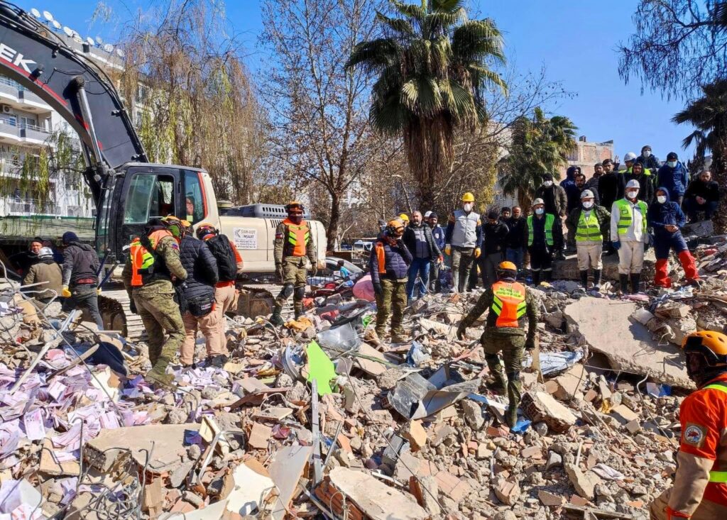
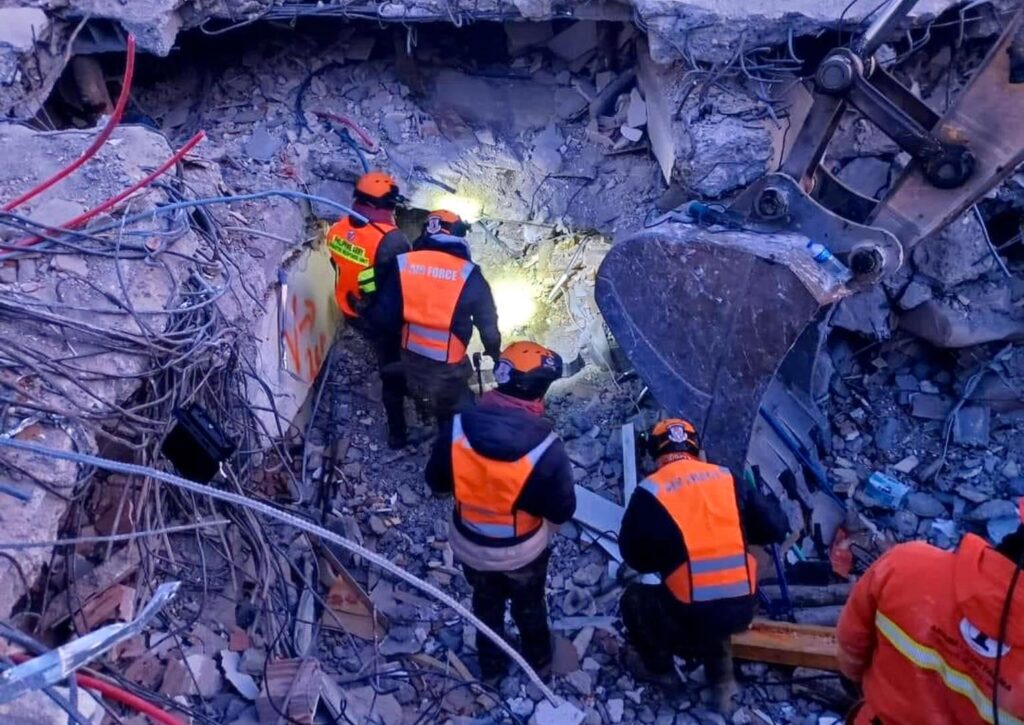
Right after the February 2023 twin earthquakes in Turkey and Syria, Mami Mizutori, head of the United Nations Office for Disaster Risk Reduction (UNDRR) issued this statement: “Of all natural hazards, earthquakes cause the deadliest disasters, accounting for 58% of total disaster deaths between 2000-2019.”
The UNDRR defines disaster as “a serious disruption of the functioning of a community or a society at any scale due to hazardous events interacting with conditions of exposure, vulnerability and capacity, leading to one or more of the following: human, material, economic and environmental losses and impacts.”
An earthquake (also known as a quake, tremor, or temblor) is indeed a serious disaster. Last March 6-7, a series of light- t0 moderate-magnitude earthquakes shook Davao de Oro and other provinces in eastern Mindanao. The series followed the magnitude 6.0 earthquake in the province last February 1, which caused tension cracks, landslides, and structural damages.
From 1891 to the present, at least 11 strong to great earthquakes – ranging from magnitude 6.0 to magnitude 8.3 (offshore) – occurred in Davao de Oro and its vicinity, according to the Philippine Institute of Volcanology and Seismology (PhiVolcs).
The most damaging earthquake that affected Davao de Oro happened on June 21, 1893; the magnitude 7.3 earthquake in Monkayo along the Philippine Fault produced numerous landslides, liquefaction, and long and wide cracks.
In his message during the First Quarter Nationwide Simultaneous Earthquake Drill (NSED) this year, Secretary Renato U. Solidum Jr. of the Department of Science and Technology (DOST) believes and expects that by now, most Filipinos must have a deeper understanding and appreciation of what an earthquake disaster means.
“It is likely that we know someone, if not ourselves, who experienced the impacts of devastating earthquakes in the Philippines in the last two decades,” the science secretary pointed out.
Just like a thief of the night, earthquakes happen anytime, anywhere. Experts believe the Philippines is now ripe for another “Big One,” a hypothetical earthquake of a 7.2-magnitude or greater. But most Filipinos don’t seem to mind it at all – until it happens.
The PhiVolcs says any active faults that have not generated any historical surface-rupturing events have higher potential to generate “The Big One.” The large quake can significantly affect the region and surrounding areas where it happens.
There are some reports that Metro Manila is apt for another big earthquake. Emmanuel De Guzman, United Nations International Strategy for Disaster Reduction advisor for Asia-Pacific, admitted that he was unsure when the catastrophic disaster would strike but it is most likely to happen in the thickly-populated metropolis.
“The big earthquake is certainly coming. The question is when? No one can tell. It can happen today, tomorrow, or next year. But certainly, there will be an earthquake,” De Guzman, who previously worked with the Office of Civil Defense of the National Disaster Coordinating Council, was quoted as saying by Philippine Daily Inquirer.
A study done by the Japan International Cooperation Agency (JICA) said Metro Manila is not ready to deal with a 7.2-magnitude earthquake in terms of existing resources and given old building structures around and within the metropolis.
The 2002-2004 “Study for Earthquake Impact Reduction for Metropolitan Manila” said that a 7.2-magnitude earthquake triggered by West Valley Fault can kill around 34,000 people, injure some 114,000 persons, partly damage an estimated 340,000 residential structures and cause the collapse of about 170,000 houses.
“Fire will break out and burn approximately 1,710 hectares and a total of 18,000 additional people will be killed by this secondary disaster,” the study said, adding that infrastructure and lifelines will suffer heavy damage as well.
But it’s not only Metro Manila that will experience the “Big One.” In fact, every region or province in the country is vulnerable to its own “Big One,” reminds PhiVolcs. This includes Davao Region.
Historical records showed a 7.2-magnitude earthquake hit Compostela Valley in 1893. On April 15, 1924, another earthquake with 8.3-magnitude happened somewhere in Sigaboy, now known as Governor Generoso in Davao Oriental.
According to the PhiVolcs official, an earthquake with an intensity of 7.2 that happened in Compostela Valley will immediately be felt in Davao City “within less than a minute” and the magnitude will be about 7.
Because of the country’s geographical location, earthquakes happen every now and then.
“Long before Filipinos settled in this country, earthquake faults were already in place,” writes Dr. Alfredo Mahar Lagmay, a professor at the National Institute of Geological Sciences of the University of the Philippines. “These faults shaped our mountains, gave birth to volcanoes, and nurtured life with warmth from Mother Earth. They are the reason for our land’s existence, and we just can’t make them disappear.”
The DOST – which is responsible for the coordination of science and technology-related projects in the country – says three tectonic plates encircle the country: the Philippine Plate in the East; the Eurasian Plate in the West; and the Indo-Australian Plate in the South.
“The existence of several fault lines across the country is a manifestation of the movements of these tectonic plates,” DOST states. Geologists define fault lines as slip-ups or cracks in a volume of rock due to rock-mass movement.
A large fault within the earth’s crust is the result of the movement of tectonic plates. A rapid movement of a fault line may produce powerful energy that can trigger a very strong earthquake, scientists say.
The country has five active fault lines: the Western Philippine Fault, the Eastern Philippine Fault; the South of Mindanao Fault; the Central Philippine Fault; and the West or Marikina Valley Fault.
Each year, about 6,000 earthquakes are detected throughout the world, according to Grolier Encyclopedia. Of the total, 5,500 are either too small or too far from populated areas to be felt directly. Another 450 are felt but caused no damage, and 35 cause only minor damage. The remaining 15, however, exact a great toll in death and suffering, besides heavily damaging houses, buildings, and other structures.
In the Philippines, at least 5 earthquakes per day occur, PhiVolcs reports. “Most are small and harmless,” Dr. Lagmay claims. “It’s the really big and shattering shakes that we need to learn to live with. Though they happen decades apart, the result is always catastrophic.”
Most people fear earthquakes because they don’t only destroy buildings and other facilities but also kill people. But “people can’t be shaken to death by an earthquake,” says Dr. Lagmay.
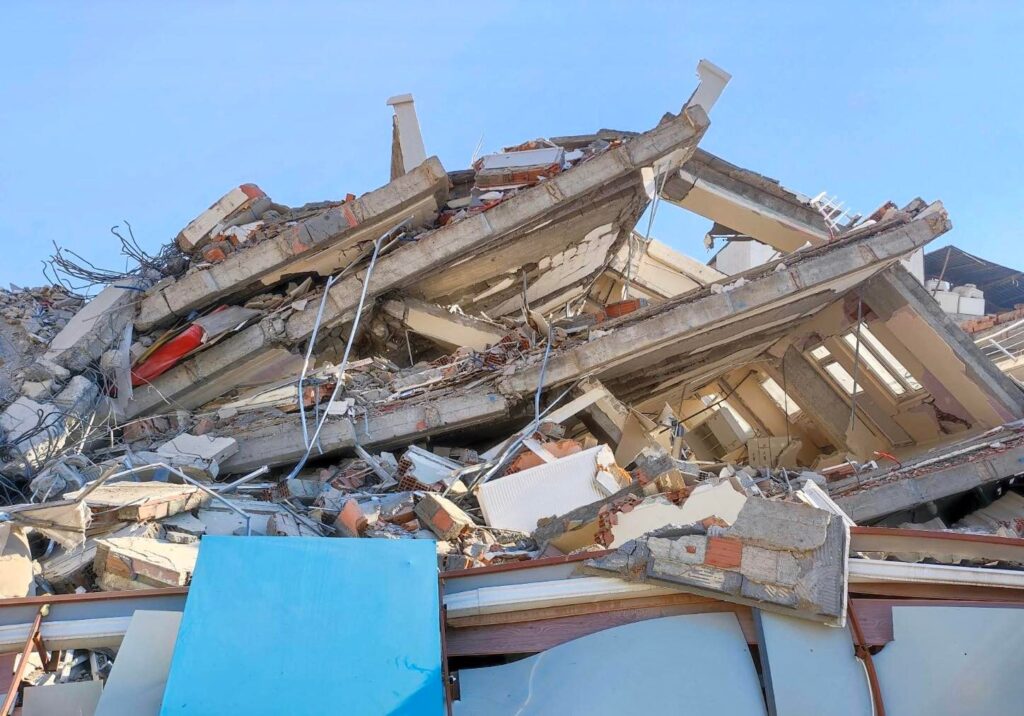
What kills people are these seven hazards: ground rupture, ground shaking, land subsidence, liquefaction, tsunamis, landslides, and fire. “The quake takes its toll when buildings and infrastructure topple down, when mountains tumble, and when the ground and water bodies heave,” Dr. Lagmay reminds.
On ground rupture, Dr. Lagmay says: “Any structure that sits directly on top of a fault can be seriously damaged when the fault moves. For this reason, no buildings are allowed within the 5-meter buffer zone from an active fault.”
Apart from ground rupture, intense ground shaking may happen away from the fault and cause buildings to topple if not built to withstand the sudden movement of the ground during an earthquake. “This hazard phenomenon is the most destructive of all the earthquake hazards,” Dr. Lagmay says.
Intense ground shaking, according to Dr. Lagmay, can cause land subsidence, making the ground elevation lower than it used to be.
“In flood plains and in coastal areas, the ground can liquefy if water in between sand and gravel mixes, turning land into slurry,” the visiting scientist at the Geophysics Department of Stanford University says. “If not firmly rooted in the ground, buildings on top of the liquefied material may tilt or collapse.”
Tsunami, a Japanese term which means “harbor wave,” happens when large ocean waves are produced when faults shift vertically. “The seismic event displaces the mass of ocean water and creates a train of waves that travel as fast as a jumbo jet toward coastal areas,” Dr. Lagmay says.
When the earth shakes, unstable mountains can fall apart and generate landslides. “Some landslides are small, scarring only the beauty of mountains. But the really big ones can travel from 2 up to 120 kilometers down slope ravaging everything in its path,” Dr. Lagmay says.
Sec. Solidum said that most Filipinos are aware that ground shaking does not kill, it is the collapsed houses, buildings, and infrastructures that kill. “Many of us know that collapsed houses, buildings, and infrastructures often are a result of flawed construction practices – meaning two things: old buildings that no longer meet current standards and the other where new buildings are unfortunately constructed that do not conform to current building standards,” he said.
Sec. Solidum argued that if Filipinos believe and accept that bad construction practices cause collapsed structures during earthquakes, then destruction and death due to the earthquake are preventable. “If bad practices are replaced by good practices,” he stressed.
“Destruction and death due to earthquakes are preventable,” he reiterated. “Let us allow the tools of science to assist us in making earthquake-resilient communities to prevent destruction and death.”
During his speech, Sec. Solidum shared some of the digital innovations and applications and tools that facilitate the interactive use of hazard and risk information for decision-making and action.
Among those presented were the following: How Safe is My House, a self-assessment tool that every homeowner should take; the FaultFinder, which tells how far away the home or workplace or school is from a source of the earthquake; the HazardHunter, another tool that tells the natural hazards that can affect the neighborhoods; and the GeoanalyticsPH, a tool that shows maps and figures the hazards assessment of the neighborhoods.
Also included in the innovations are PlanSmart, which gives national and local planners the necessary information needed for their development planning needs; and REDAS (Rapid Earthquake Damage Assessment System), a software which teaches local planners to build the exposure database and the scenarios of earthquake, tsunami, and landslide hazards that they will use in their Comprehensive Land Use Plans (CLUPs).
“DOST continues to develop various applications to make science more accessible in decision-making for prevention and mitigation and encourage everyone to use them as our good practice,” Sec. Solidum concluded.
As Maria Elena Paterno wrote in her book Earthquake!: “The only way to avoid disasters caused by earthquakes is to prepare for them.”