

By Henrylito D. Tacio
Credits: Photo by PHIVOLCS, Table of deadliest recorded earthquakes in the Philippines from Wikipedia
In the Philippines, disasters are not waiting to happen; they happen now and then. As Kathleen Tierney, director of the Natural Hazards Center at the University of Colorado, puts it: “The Philippines is one of the most disaster-prone places on Earth. They’ve got it all. They’ve got earthquakes, volcanoes, floods, tropical cyclones, landslides.”
“The Ring of Fire” is what scientists call the area in the Pacific Ocean basin where a large number of earthquakes and volcanic eruptions occur. Unfortunately, the Philippines – a country with 7,107 islands – is located in this rim, sometimes called the circum-Pacific seismic belt.
About 90 percent of the world’s earthquakes and 81 percent of the world’s largest earthquakes occur along the Ring of Fire. The recent earthquake that hit Bohol is proof of it. On the morning of October 15, 2013, a destructive earthquake shook the island noted for its Chocolate Hills and endangered tarsier.
The earthquake was recorded at a magnitude of 7.2, which has an energy “equivalent to 32 Hiroshima bombs.” The Little Boy atomic bomb dropped on Hiroshima, Japan, on August 6, 1945, packed power equal to 20,000 tons of TNT.
Coming soon: earthquake in Metro Manila
Metro Manila, home to more than 10 million, is not spared from earthquakes. Wikipedia reports that on June 25, 1599, history records showed that an intensity 6 quake struck the city. The quake had damaged many private buildings and the city and ruined the roof of Sto. Domingo Church.
Only 11 years later, on November 10, an intensity 9 quake hit Manila again. It was considered “a terrible quake” that progressed from east to west. On June 19, 1665, and intensity 8 quake struck Manila; only a Jesuit church experienced great damage. About 19 people were reported dead.
On June 3, 1863, an earthquake reportedly destroyed the Manila Cathedral, the City Hall, the Governor’s Palace (all three located at the time on Plaza Mayor, now Plaza de Roma), and much of the city.
There are some reports that Metro Manila is apt for another big earthquake. In a news report, Emmanuel De Guzman, United Nations International Strategy for Disaster Reduction advisor for Asia-Pacific, admitted that he was unsure when the catastrophic disaster would strike. Still, it is most likely to happen in the thickly-populated metropolis.
“The big earthquake is certainly coming. The question is when? No one can tell. It can happen today, tomorrow, or next year. But certainly there will be an earthquake,” De Guzman, who previously worked with the Office of Civil Defense of the National Disaster Coordinating Council, told the Philippine Daily Inquirer.
Recently, the Department of Science and Technology, through the Philippine Institute of Volcanology and Seismology (PHIVOLCS), distributed the Valley Fault System (VFS) Atlas to local government officials.
The handbook has large scale maps showing in detail areas traversed by the Valley Fault System, an active fault system in the Greater Metro Manila Area (GMMA). The fault system has two fault traces: the 10-kilometer long East Valley Fault in Rizal and the 100-kilometer long West Valley Fault that runs through different cities and towns in Bulacan, Rizal, Metro Manila, Cavite, and Laguna. The West Valley Fault can generate a large earthquake, which poses a threat to people’s lives, buildings, infrastructure, and livelihood.
A study done by the Japan International Cooperation Agency (JICA) said Metro Manila is not ready to deal with a 7.2-magnitude earthquake in terms of existing resources and given old building structures around and within the metropolis. The JICA study showed that such magnitude would result in major fires in Manila, Pasig, and Quezon City. Fire hydrants will not be enough to take seven days before authorities can declare “fire out” as major fire engines come from Quezon City and Pasig City, areas that are also at high risks.
A 7.2 magnitude earthquake can shake the ground even a hundred kilometers away, which means the whole of Metro Manila and its surrounding provinces can be shaken, PHIVOLCS director Renato Solidum Jr. was quoted as saying by GMA News Online. Areas near the waters like Marikina Valley down to Manila de Bay are also more likely to experience stronger ground shaking due to the softer ground they sit on.
6,000 earthquakes each year
According to the Grolier Encyclopedia, about 6,000 earthquakes are detected throughout the world each year. Of this, 5,500 are either too small or too far from populated areas to be felt directly. Another 450 are felt but cause no damage, while 35 cause only minor damage. However, the remaining 15 can exact great tolls in death and suffering, besides heavily damaging houses, buildings, and other structures.
An earthquake (also known as a quake, tremor, or tremblor), according to a monograph circulated by the PHIVOLCS, “is feeble shaking to violent trembling of the ground produced by the sudden displacement of rocks or rock materials below the earth’s surface.”
The earth has an outermost shell, about 80-kilometer thick, which is solid and rigid. This shell is called the lithosphere, subdivided into small and large pieces with some pieces large enough to contain continents. These pieces of the lithosphere are called tectonic plates.
So-called faults are breaks or zones of weaknesses in rocks along which displacements have occurred or can occur again. They may extend for hundreds of kilometers downward, even down to the base of the lithosphere. Faults showing signs or documented history of recent displacements are called active faults.
The Philippine Archipelago lies between two major tectonic plates: the Philippine Sea Plate and the Eurasian Plate. “Philippine Sea Plate is moving towards the Philippine Archipelago at the rate of about 7 centimeters every year,” PHIVOLCS explains. “The Eurasian Plate is being subducted along western side of Luzon and Mindoro at the rate of 3 centimeters per year except on Mindoro and northwest of Zamboanga where collision is taking place.”
At the intersection of the two aforementioned plates is the Philippine Fault Zone, “which decouples the northwestward motion of the Pacific with the southwestward motion of the Eurasian Plate.” Movements along other active faults are reportedly responsible for the present-day high seismicity of the Philippine archipelago.
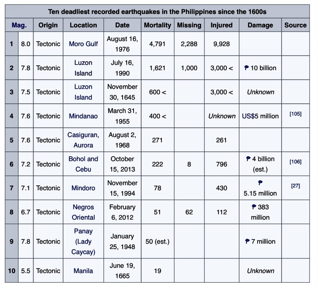
According to PHIVOLCS, at least 5 earthquakes per day occur in the Philippines. For almost four decades now, the country has been affected by 10 earthquakes with a magnitude greater than 7.0. As such, the possibility of these destructive earthquakes occurring again in the future “is very strong.”
Hazards posed by earthquakes
The destructive effects of earthquakes are due mainly to intense ground shaking or vibration. “Because of severe ground shaking, low and tall buildings, towers and posts may tilt, split, topple or collapse, foundation of roads, railroad tracks and bridges may break, water pipes and other utility installations may get dislocated, dams and similar structures may break and cause flooding, and other forms of mass movement may be generated,” PHIVOLCS explains.
Liquefaction, the process where particles of loosely consolidated and water-saturated deposits of fine sand are rearranged into a more compact state, can also occur. Liquefaction prone areas can be found in beach zones, sand spits, sand bars, wide coastal plains, deltaic plains, floodplains, and former or existing marshlands and swamplands.
Many strong earthquakes originate along faults that break the earth’s rigid crust, called a ground rupture. It is a deformation on the ground that marks the fault plane’s intersection with the earth’s surface.
Landslides, the downward movement of slope materials either slowly or quickly, are most likely to happen. Hilly and mountainous areas, escarpments, steep river banks, sea cliffs, and other steep slopes are prone to landslides.
Earthquakes can also cause tsunamis. “Tsunamis are giant sea waves generated mostly by submarine earthquakes,” PHIVOLCS says. “Not all submarine earthquakes, however, can cause tsunamis to occur.”
Always be ready
“The only way to avoid disasters caused by earthquakes is to prepare for them,” wrote Maria Elena Paterno in her book Earthquake! This must be the reason why PHIVOLCS urged every Filipinos to evaluate the structural soundness of the home, office, and buildings they frequent. “Determine the safest areas both inside and outside,” said a PHIVOLCS primer.
The primer also recommends that every home must be prepared for the eventuality. “Secure heavy furniture to prevent sliding or toppling over by affixing them to walls or floors with brackets or tying to grillwork. Keep heavy objects on lowest shelves. Check hanging objects (like ceiling fans, mirrors, heavy picture frames). Affix bolts or hooks on cabinet doors especially those in the kitchen to prevent them from flying open and allowing breakable items to spill out. Keep only very necessary chemicals and flammable liquids in unbreakable containers. Store them on low shelves.”
The PHIVOLCS primer also suggests setting up an earthquake readiness plan at home. “Make sure your children, elderly members and house helpers are properly instructed on what to do. Practice drills with them. Familiarize yourself with First Aid procedures. Keep a manual handy in case you forget. Make sure everyone knows the locations of and how to switch off the electrical and water mains. At home (and at work), master the quickest, safest way out,” it says.
The primer also recommends preparing a small bag – no more than 5-6 kilograms – for each family member. Among those that should be packed inside the bag are two changes of clothes, a blanket, a towel, basic toiletries, sturdy shoes, flashlight, batteries, a bottle of water, biscuits candy, a small radio, any medications for chronic ailment suffers, first aid kit, contact phone numbers, and addresses. Important papers (passport, recent medical records, bank books, insurance papers, etc.) must also be included.
What should a family do during an earthquake? The primer says: “Stay calm. Call out instructions to children or others who seem to be in panic.”
If you happen to be inside a structurally sound building during an earthquake, you must stay there. However, if you have doubts about the building, leave immediately by the safest, quickest route.
Once you are outside the building, look for an open area where you can stay. But you must stay away from power lines, telephone poles, and trees. If objects are falling, brace yourself in the doorway of a building.
If driving, pull over and stop. You should not cross bridges, over or underpasses. If on a mountain road, pull over and stay clear of ridges. If by the sea, move inland to higher ground.
After an earthquake:
- Check yourself and other members of the family.
- Check for fire, chemical spills, and act on them right away.
- In case of doubt about leaks or damage, switch off all electric main fuse and turn off gas tanks.
If you must evacuate, take your small bag with you and leave a message with a contact person as to where you are headed. Do not go sightseeing.
Be prepared for aftershocks. Do not enter damaged buildings because aftershocks can finish them off.
It is said, and you should heed this, that natural calamities like earthquakes happen when you have forgotten about them.