
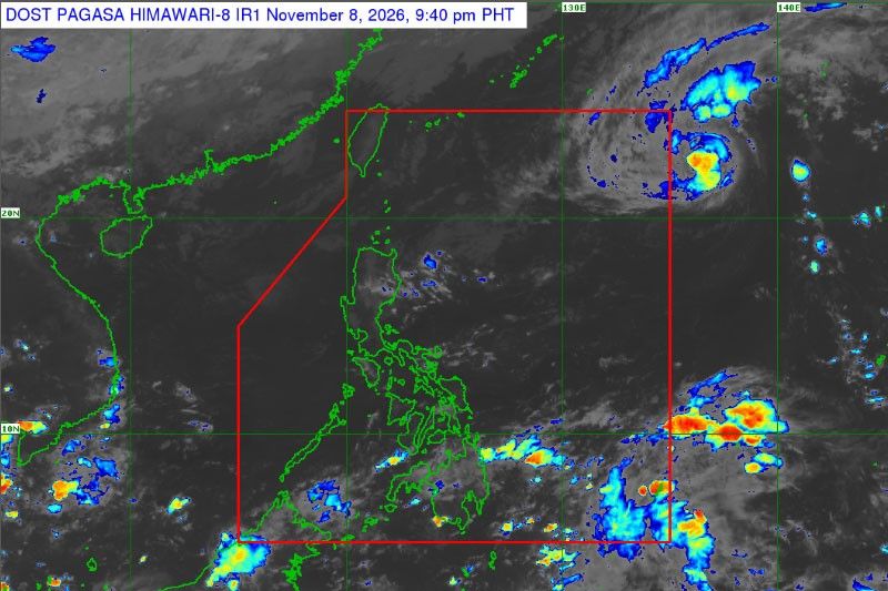
Typhoon Cempaka is expected to enter the Philippine Area of Responsibility (PAR) on Monday, November 9, and will receive the local name Samuel once it enters the country’s monitoring zone, according to the Philippine Atmospheric, Geophysical and Astronomical Services Administration (PAGASA).
As of 3:00 AM Monday, the typhoon was located approximately 1,440 kilometers east-northeast of extreme Northern Luzon. It had maximum sustained winds of 120 kilometers per hour near its center and gustiness of up to 150 kph.
PAGASA reported that Typhoon Cempaka was moving west-northwestward at 15 kph. Despite its strength, the weather bureau does not expect the system to make landfall or directly affect the Philippines under its current forecast track.
Expected Track of Typhoon Cempaka
After entering PAR, the typhoon is forecast to turn north-northeastward before moving out through the northeastern boundary of the country’s monitoring area.
PAGASA expects the weather system to remain over the Philippine Sea, far from land. Its movement will continue to be monitored as forecasters assess whether any changes in its direction or intensity could affect the forecast.
Entering PAR does not automatically mean a tropical cyclone will make landfall. The area is a monitoring boundary used by PAGASA to track tropical cyclones that may potentially affect the Philippines. A storm can enter and leave PAR without crossing Philippine land.
Rain Expected in Parts of the Philippines
While Typhoon Cempaka is not expected to directly affect the country, other weather systems will bring rain to several areas on Monday.
PAGASA forecasts cloudy skies with scattered rain showers and thunderstorms over Caraga, Camarines Norte, Camarines Sur, Catanduanes, Albay, Sorsogon, Davao Oriental and Davao Occidental due to the easterlies.
Meanwhile, the Northeast Monsoon, locally known as Amihan, will bring cloudy skies with rains to Cagayan, Isabela, Quirino, Apayao, Kalinga, Mountain Province, Ifugao, Aurora and Quezon.
Moderate to occasionally heavy rainfall could trigger flash floods or landslides, particularly in areas vulnerable to these hazards.
Residents are advised to monitor official PAGASA bulletins and follow announcements from their respective local government units.
PAGASA will continue monitoring Typhoon Cempaka as it approaches and enters the Philippine Area of Responsibility.

 Facebook
 Twitter